When officials at the University of South Florida began tracking the massive Hurricane Dorian looming over the Caribbean earlier this month, they immediately knew what they had to do.
"We’re using it in a responsive way," she said. "Some people say it's cutting edge — which in some ways it is — but it’s a responsive way to use the technology."
With technology already on the ground that gave a bird's-eye view of the structure in place, USF students and faculty began working to put the pieces together once the infrastructure became a pile of rubble in the hurricane's wake.
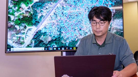
Here's how it works: A graduate student with an interest in this topic pulls a pre-satellite image and manually digitizes and assesses the rooflines, which are cross-referenced using geographical points. The post-storm aerial imagery, as it's called, creates an image of all the rooflines and assesses how much they have been affected by the storm.
"Some will do dots on a map saying, 'Here’s a house, this is the footprint of the structure," Collins said. "Which is important in recovery efforts, because we want to understand the configuration and shape. You can't make out anything (on the ground); it's a pile of rubble. So to understand what was there before is an important asset."
The efforts will help the boots on the ground use augmented reality to project the data sets given to them by the USF team. This way, they will know where exactly to look among the piles of destruction. According to the National Emergency Management Agency, as of Sept. 12, 1,200 people were still considered missing.
The technology is also used for environmental purposes, like monitoring an oil spill, and for historical preservation purposes. Collins is hopeful that eventually a computer can be taught to do the work that currently has to be manually drawn.
Collins said the team will continue to send data sets to the Caribbean over the next few weeks, with their eyes on long-term goals and implications.
"In the long term we can develop this for historic preservation and structural impact," she said. "These kinds of problems have universal application. So anything we learn from these projects and anything the students have done will have long-term benefits."