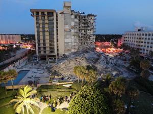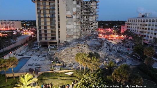
A recent Florida International University study determined the Champlain Towers South Condo, the beachfront building in Surfside that unexpectedly collapsed June 24, had been slowly sinking since the 1990s.
The same technology that powered the 2020 study could be used to detect other structures that could be vulnerable to sea level rise, sinkholes and other natural disasters, according to Shimon Wdowinski, the researcher who led the study.
Wdowinski, a professor in the university's Department of Earth and Environment, said the land and sea level rise study analyzed space-based radar images of Miami Beach collected from 1993 to 1999. The research identified the 12-story Champlain Towers South Condo as a location on the island where land subsidence – the gradual settling or sinking of the Earth's surface – was detected. The study found the building was sinking at a rate of nearly 2 millimeters a year.
"That movement alone cannot explain the collapse, but the satellite images show us movement did occur," said Wdowinski, an expert in space geodesy, natural hazards and sea level rise.
Completed in 1981, the condominium was in the early stages of its 40-year recertification process before a section of the building pancaked into tons of rubble, causing at least 11 confirmed deaths. Officials have not yet determined the cause of the collapse.
In the 1990s, Miami Beach as a whole experienced subsidence at a rate of 1 to 3 millimeters a year, adding up to a few inches over a decade, according to the FIU study. That was less movement than Mexico City, another city the researchers focused on, which is subsiding at a rate of 15 inches a year.
The study relied on synthetic aperture radar, a form of radar used to obtain information about the Earth's terrain. SAR systems, often mounted on airborne or space satellite sensors, measure distances between the sensor and a point on the Earth's surface where the signal is backscattered. That data can be used to create two- and three-dimensional image reconstructions of landscapes.
Although the study was released last year, Wdowinski said the research was the last thing he thought about when he first saw the news about the condo collapse.
"It was completely shocking to me," he said. "I wasn't thinking about the research; I was thinking about the disaster and the people experiencing it."
He said he didn't remember the study had specifically named the Champlain Towers South Condo as a structure where land subsidence was detected until media outlets found it online and began contacting him.
Wdowinski said he believes SAR technology could be used on a wider scale to pinpoint structures that may be compromised by land subsidence or sinkholes, another hazard that plagues Florida.
"The technology could be used as a safety measure to flag infrastructure and buildings that could be problematic," he said.
Sign up here for the Business Journal’s free morning and afternoon daily newsletters to receive the latest business news impacting South Florida. For more business intelligence, follow us on LinkedIn, Facebook, Twitter and Instagram.