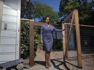
Sylvia Wu and her husband have a home on 20 acres in the tiny, rural hamlet Corralitos in the Santa Cruz Mountains.
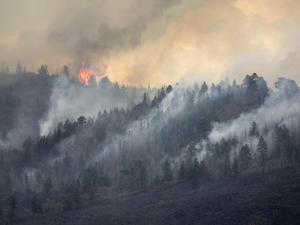
Last summer, as the CZU Lightning Complex fires raged over 86,000 acres in the area, smoke blackened the sky and some of her neighbors were asked to voluntarily evacuate.
While Wu’s home was not directly threatened, the severity of the fire season meant that keeping her family and property safe became “top of mind.” Drawing on once-forgotten fire service brochures about defensible spaces around her home, she and her husband (along with occasional hired help) started to raise the canopies of surrounding trees and clear foliage and brush on the property.
“We were slowly chipping away at it, but with only a couple people it goes super slowly,” Wu told me.
As this year’s fire season started to ramp up, a solution came in the form of a former co-worker, Jahan Khanna, whose new San Francisco startup Firemaps specializes in home hardening, essentially helping homeowners make their properties more resilient against wildfire risk.
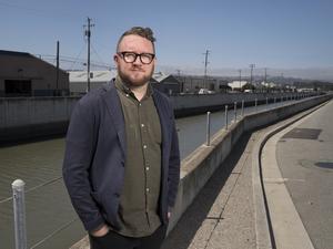
Khanna, who previously helped start ride-share startup Sidecar and worked as director of product at Uber, founded Firemaps earlier this year with Rob Moran and his brother, Sharuk, a civil engineer. The five-person company, which recently launched its service statewide, has raised $5.5 million in seed funding from Andreessen Horowitz, Uber CEO Dara Khosrowshahi and investor Lee Fixel.
“Just being in California I’ve known several colleagues that have had their properties burn down. It’s inescapable here,” Khanna said. “I think, though, we know what needs to be done. Over the course of the next several years we’re going to need to adapt to this new normal. There are millions of homes at high fire risk and those need to be defended. Once we defend those locations, we can start to move out and be more proactive about land management and land defense.”
According to a report from the UC Berkeley Center for Community Innovation, more than one in 12 Californian homes is located in an area identified as having a high risk of burning in a wildfire event, with researchers cautioning that the number is likely a undercount.
The problem for homeowners, according to Khanna, is there is no organized system to actually get the work done to harden a home against fire risk.
Here’s how Firemaps approach works: A homeowner puts their address into Firemaps’ system, which pulls satellite imagery and other data such as when the home was constructed and vegetation level to provide an overall risk assessment on the property.
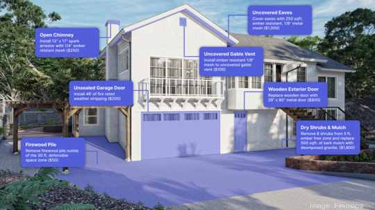
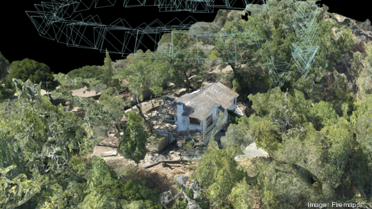
From there, the company works with a statewide network of drone operators to perform an onsite inspection using 3D mapping to create an accurate model of the property and home itself. Using this information, Firemaps provides a series of recommendations in line with state, local and insurance guidelines and connects homeowners with contractors and tradespeople to actually follow through on those suggestions.
Khanna’s elevator pitch: Think something like Angie’s List on steroids with drones.
The startup’s revenue model is focused on the last part of the process. The initial risk assessment is free, along with the drone modeling, but contractors pay a fee to be listed on Firemaps and the company takes a cut of the work enabled through the platform.
After a contractor successfully bids on the work, Firemaps essentially functions as the project manager keeping track of work and verifying the job gets done according to insurance and legal specifications. That has become increasingly important as insurance companies look to drop policyholders from coverage amid skyrocketing fire risk.
“Basically everyone needs this kind of platform to understand what should be done and what actually has been done,” Khanna said. “We think putting them in place will facilitate an environment where we really can be proactive about this at the scale of millions of homes.”
In Wu’s case, she and the Firemaps team went back and forth balancing fire risk with cost and aesthetic concerns, eventually deciding on a number of improvements including cutting down a bamboo grove and clearing shrubs and other trees. She also decided to put down a decomposed granite path around her home, using the fire-retardant material to build a defensive moat around the property and give firefighters a safe path to combat a potential fire.
“With the amount of work we did, I personally think for people who have a lot of vegetation on the property, you simply wouldn’t be able to do it if you chipped away every weekend,” she said.
As the state heads into yet another unprecedented fire season, Wu said the improvements made via Firemaps gives her additional confidence to live through the current reality of life as a California homeowner.
“For me it’s never going to be peace of mind, but I want to at least know that I did everything I can,” Wu said.