With the recent news that the Gulf Stream could be on the brink of collapse, a mission to gather new data at the University of Rhode Island could be vital in understanding what’s next.
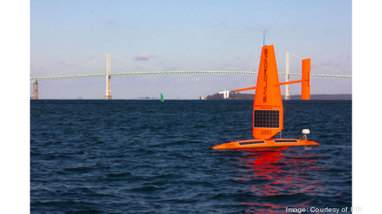
After a large grant from Google in April, researchers at URI's Graduate School of Oceanography, in conjunction with the company Saildrone and the European Center for Medium-Range Weather Forecasts (ECMWF), have launched three uncrewed Explorer drones to trawl the ocean's surface and gather a “first-of-its-kind” data set.
Associate professor Jaime Palter, who serves as co-principal investigator of the mission, said the data sets will be used to answer all kinds of questions about ocean carbon uptake — the ability of the ocean to absorb carbon — more precisely. Palter said these new numbers would also be used to boost the accuracy of long-range weather forecasting.
“First, we want to sharpen the numbers and see how well previous estimates of ocean carbon uptake are,” she said. “Next, we want to examine scales of variability that have literally never been measured. For instance, it looks like the wind speed and direction influence how much CO2 the atmosphere carries over the ocean, likely because the Gulf Stream is directly down-wind of the highly industrialized eastern US. Does this variability influence the size of the ocean uptake? We hope to find out shortly.”
Palter said the data will be freely shared with the oceanographic community, which she hopes will create opportunities to address research questions that haven’t been thought of yet, especially where chemistry is concerned. Working alongside Ph.D. student Sarah Nickford and postdoc Linquan Mu, Palter said after they receive new data the team will be able to create more detailed maps of air-sea carbon exchange across the Gulf Stream.
“Every year, the ocean absorbs about a quarter of anthropogenic CO2. But the uncertainty on the global ocean CO2 uptake is larger than we'd like,” she said. “The Gulf Stream region is one of a few places known to be a fast-track for ocean carbon uptake. We want to get a better handle on the exact numbers and a greater understanding of the contributing processes.”
URI's partnership with Saildrone dates back to 2019, when Palter worked with collaborators to launch a single Saildrone in the Gulf Stream for a month. After 19 days, it was almost destroyed by a breaking wave the size of a three-story building.
“The wave snapped its rigid wing (the sail that powers it through the water),” she explained. “Since that mission, Saildrone designed a hurricane-wing that is shorter and tougher under breaking waves and successfully sailed it into the eye of a hurricane this summer.”
Because the newer versions aren’t as maneuverable and don’t provide as much power, this new mission will be using similar technology to that used back in 2019.
“It is a risk, but the company has an expert mission team that will be monitoring it very actively, and using all the sailing techniques at their disposal to keep it safe during very rough conditions,” she said.