![Garimella headshot[10723]](https://media.bizj.us/view/img/12585210/garimellaheadshot10723*540xx1781-2374-180-0.jpg)
Weather app MyRadar has built its business using satellite data from government sources, and now it is building its own satellite capabilities to help users understand the threat of wildfires.
The company was awarded a $650,000 Phase II grant from the National Oceanic and Atmospheric Administration for its Orbital Wildfire Resilience project. This is on top of a $150,000 Phase I grant that was awarded last year, said Sarvesh Garimella, chief technology officer and project principal investigator on the project.
The Orbital Wildfire Resilience project aims to put small satellites in orbit that can identify wildfire threats or smoke plumes and then send alerts to MyRadar users. It’s part of the company’s overall goal to give people situational awareness so that users can make more informed decisions.
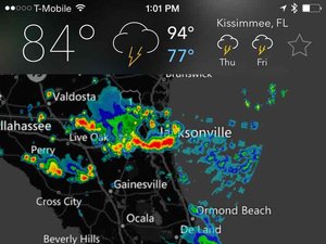
The company already does this with its weather app that uses data from NOAA and NASA satellites and sends alerts. However, there are limitations to the kinds of data those satellites provide, such as time delays, said Garimella. The NOAA satellite could warn of certain hazards but the information might not come through for several hours or the next day.
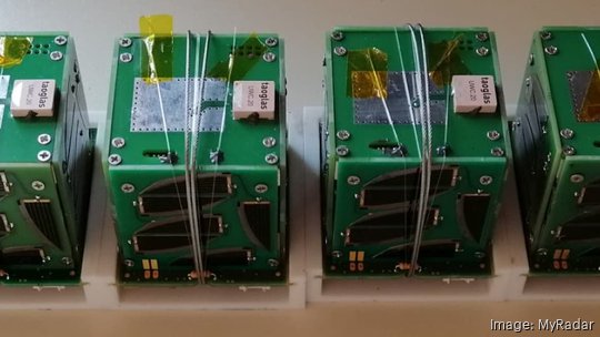
With more private options available for launching satellites, the costs have come down to the level where a company of MyRadar’s size can put its own satellites up. The first prototype for MyRadar’s satellite program launched in 2019.
That project was self-funded, and the company worked with an amateur satellite club. By 2021, the company was tapping into the SBIR/STTR program receiving contracts from the U.S. Air Force and U.S. Navy and then the NOAA grants.
At the same time, the company is raising an equity crowdfunding round that can go up to $5 million. The raise is happening on the site StartEngine. So far, the company has raised $1.1 million from 786 investors at a $70 million valuation.
Last year the company launched three more prototypes. It expects to launch the next iteration of its satellites around the third quarter of 2024.
Creating its own satellite program has been a natural step for the company. And monitoring wildfires also made sense.
“With the (weather) app we find the situational awareness utility is beyond a single rainstorm or hazard. There are typically multiple hazards at play,” said Garimella. “The wildfires in Maui are a perfect example. There was a hurricane in the area that created extra winds that exacerbated the conflagration.
“The reality is in the 21st century climate the occurrence of multiple hazards at the same time is more probable,” he added.
The company’s ultimate plan is to use a series of its own satellites for global coverage and allow for sub-hourly alerts as needed. The tiny satellites, which are 10-centimeter cubes, contain onboard sensors and context artificial intelligence. When the AI sees something of interest other systems kick on and send information back to the company’s servers.
Information can then be sent to users, said Garimella.
The company already sends 3 billion to 4 billion push notifications a year based on its existing weather app. New notifications based on the new satellite data would add to that, he said.
“We had more than 10 million users in a single day when a hurricane was making landfall,” he said. “We spend a lot of time and effort from a technology perspective to make sure the products don’t fail when millions of people use them.”
MyRadar has about 32 employees full-time employees, with seven of them based in Portland with Garimella. At any given time it also has another six to 12 contractors. With this added grant money Garimella plans to add support to his team. The satellite team is currently six people.
With this added grant funding and others in the pipeline the company is planing to hire. Garimella said he is interested in adding hardware engineers and machine learning and AI software engineers. The company recently hired a drone testing engineer out of Portland State University’s aerospace program, he added. The team has tapped into the PSU program at various times.