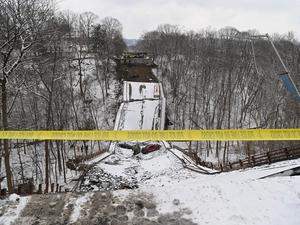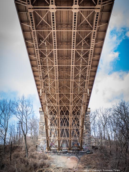
The January collapse of the Fern Hollow Bridge has resulted in opportunities for bridge inspecting-capable Pittsburgh startup companies to deploy their own relevant technologies around the region, efforts that will offer them real-world validation of their products as these companies look to build their own bridges to scale and grow themselves.
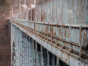
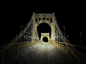
One of the first startup companies to jump into action following the bridge collapse was Mach9 Robotics, a Bloomfield-based startup company that uses robots and sensors to map surface and subsurface areas that can then be converted into geospatial renderings of critical infrastructure. It's able to do this in a matter of minutes instead of what would usually take teams of people months to accomplish. Put another way, the startup company can show the layouts of critical infrastructure in a configuration that's similar to what Google has been able to do to the planet with its Google Earth product.
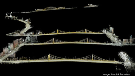
The company's CEO and co-founder Alexander Baikovitz announced the formation of the Pittsburgh Bridge Initiative a few days after the Fern Hollow Bridge collapse, a plan that calls for Mach9 to deploy its technology across municipalities to map and then display the city's nearly 450 bridges in a way that's never been done before.
It's an effort that Baikovitz said will look to partner with the Pennsylvania Department of Transportation, the Pennsylvania Turnpike, the City of Pittsburgh, Allegheny County and the Commonwealth of Pennsylvania as well as civil engineers, land surveyors and construction firms to better see the unseen as it relates to potential underground infrastructure weaknesses in areas that surround the city's bridges.
"What we're focused on within this initiative is learning more about how can we build technology that helps the bridge inspectors, that helps engineers and regulators understand information in a traceable, understandable, less biased way," Baikovitz said in January. "And then the second component is, how do we actually enable huge-scale mapping? We're doing things that really haven't been done by small entities before, typically it's been reserved for massive surveying companies, civil engineers or technology companies to do this, but we're creating this grassroots movement where we're figuring out how to create these ultra-high-definition maps of effectively entire cities."
The company has embarked on beginning to map Pittsburgh bridges and hopes to land contracts and partnerships down the road to work with Pittsburgh, other municipalities and transportation agencies.
AERAS, a local drone startup company, is looking to offer a similar level of analysis of the city's bridges, but unlike Mach9's ground-level approach, AERAS will take to the sky with its drones to scan the hundreds of bridges found throughout the city limits. It's hoping to share its findings with partnering engineers and policymakers to help them identify infrastructure and stability issues that could be found in a bridge.
"Last month’s collapse of the Fern Hollow Bridge highlights the need for increased monitoring of infrastructure not only here in Pittsburgh, but across the nation," AERAS CEO and Co-Founder Eric Lloyd said in a statement. "Engineers have a huge undertaking ahead of them here in the ‘City of Bridges’ — and, honestly, across the country — to make sure motorists are traveling on the safest infrastructure possible."
The startup already uses its unmanned aerial vehicles for commercial sanitization efforts as well as for exterior building and window washing. AERAS can also deploy its drones for agricultural and public safety-related needs.
Now it's adding bridge inspection to its list of possibilities. Its precision LiDAR and photogrammetry capabilities allow the startup's drones to scan a bridge in under 30 minutes, which results in a collection of thousands of images and data points to help engineers and inspectors see a level of bridge inspection that previously would have been impossible to gauge.