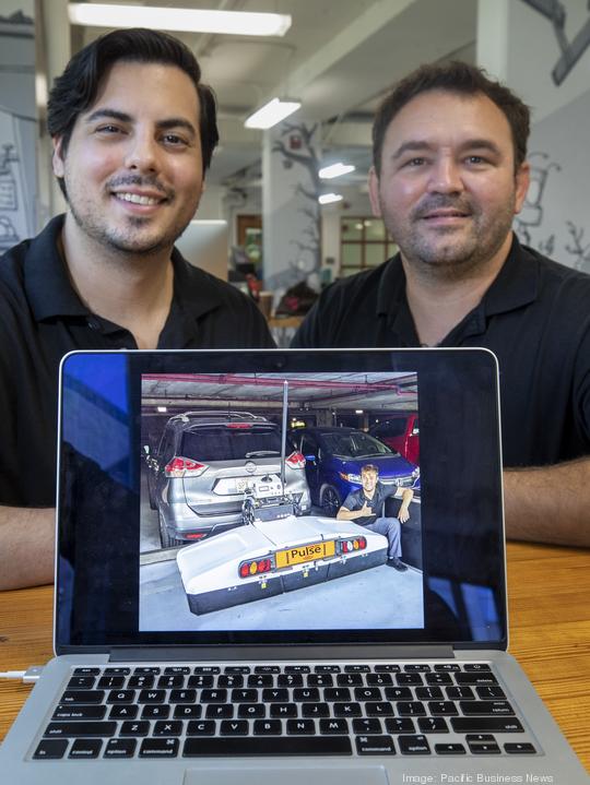
When two former Navy nuclear submariners stationed in Hawaii separately signed up for the same STEM program at Honolulu Community College in 2019, it was at once a coincidence and the start of something special.
There, Craig Opie, 36, and Anthony Lopez, 31, collaborated on a concept for a new method of scanning hidden and hard-to-detect underground objects, such as water mains and electrical wires, that can prove messy for project managers and construction foremen.
Pulse Utility launched in January and soon won three competitions — the Innovation Impact Challenge sponsored by Hawaiian Telcom, the University of Hawaii Venture Competition, and the National Science Foundation Innovation Corps contest at Arizona State — that helped it gain the near $65,000 in capital it needed to build its first working device.
Pulse’s team of five is convinced its method can save developers time, energy and money — about 25% annually, it estimates — on utility location costs compared to the decades-old existing method for finding utilities, the toner method, which involves pinging a current along a utility line and tracking it.
“It’s very time consuming and not easy,” said Opie, the company's CEO, who is from Daytona Beach, Florida. “That’s the eye-opener for us — ‘hey, this is really an area that needs improvement.’”
And there is a need. The Common Ground Alliance’s DIRT, or Damage Information Reporting Tool, report revealed 400,000 excavation-related incidents in 2019 and estimates $30 billion in annual U.S. costs due to damaged infrastructure.
Pulse’s concept is a crossing of existing technologies to combine ground penetrating radar, or GPR, with augmented GPS to within accuracy of a centimeter. They tow their 100-pound device over roadways or other targeted areas of ground, and it collects the data and sends it to their software program, which uses a 3-D overlay of Google Earth. Users can zoom in on specific areas of roadway and see the utility lines highlighted in various colors.
“Being in the Navy, I realized that wanted to be my own boss,” said Lopez, the COO from New Orleans. “And so getting out, I was always looking for that one moment to take advantage of, that would let me be able to do that. Oddly enough, Craig has pursued that route, and he’s believed in me, which is amazing, and he knows my capabilities. He showed me the problems and I came up with the solution, and we both saw the opportunity in front of us.”
Their team includes Isaac Rodrigues, the company president who has experience building devices to detect underground IEDs, or improvised explosive devices, on battlefields.
Lopez came up with the idea of attaching their device on a flying drone to really unlock the technology, but currently it is not permitted to attach a radar on a drone due to FAA and FCC rules. They are in the process of submitting a proposal to change that.
Pulse Utility’s first job was scanning the University of Hawaii’s Clarence T.C. Ching Athletics Complex field during this year’s overhaul of the facility to prepare it for football games. Afterward, UH Vice President for Information Technology and chief information officer Garret Yoshimi said the startup would be invaluable for future projects with an underground infrastructure component.
As for the urban core — Pulse’s real target — it mapped over 75 square miles of Honolulu within about two weeks. Opie and Lopez said they’ve scanned 90% of the remainder of the projected railway path of the Honolulu Authority for Rapid Transportation, including the dense Dillingham corridor area that has caused consternation and delays for years because of its cluster of underground utilities.
“Even from the beginning, we set our signs on tackling the railway, and HART, and the problems that they’re seeing over on Dillingham,” Opie said. “That’s what we tuned our model for, is different projects in that scope.”
So far, they have not reached a partnership, Opie said, as contracts have already been awarded and those contractors are not eager to sub-contract out money they’ve counted on.
[UPDATE: HART Interim Executive Director Lori Kahikina responded to PBN's inquiry on the possibility of using Pulse Utility's services: "From 2016 through 2018, HART engaged a different company, through the standard procurement process to conduct utility location and mapping throughout the City Center corridor. HART chose that company because of their experience, equipment, and broad range of technologies.
"Pulse Utility was not founded until 2020, so they were not an option at the time HART procured the utility mapping work. However, if Pulse Utility already has data from other projects in the corridor, then it may be cost-effective to obtain that data."
PULSE UTILITY LLC
Craig Opie, CEO, and Anthony Lopez, COO
Phone: 808-238-9966
Email: service@pulseutility.com
Website: pulseutility.com
Facebook: facebook.com/pulse.utility
