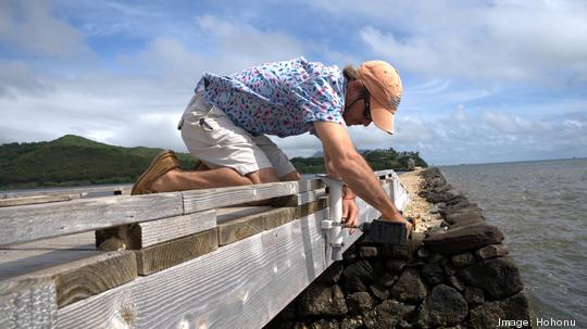
Hohonu, a two-year-old Hawaii-based startup company that uses its own sensors to detect sea level rise, has been commissioned by a regional member of the National Oceanic and Atmospheric Administration, or NOAA, to assist East Coast communities on the Mainland.
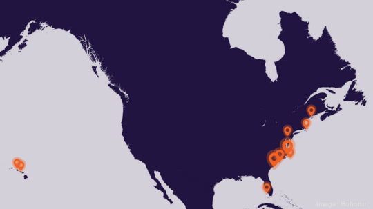
The public-private partnership company, which is partially owned by the University of Hawaii and other nonprofits, is deploying more than 40 sensors along the coast between North Carolina and Florida over a five-year period in partnership with the Southeast Coastal and Ocean Observing Regional Association, or SECOORA.
Hohonu originated out of UH oceanography professor Brian Glazer's lab in 2014.
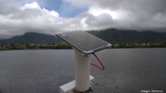
Glazer started by installing the sensors with various Hawaiian fishpond restoration groups, which Hohonu still works with. His team started custom building the sensors with increasingly cheap component parts, allowing for the devices to be made for many times less than what it would cost a NOAA team to install a $500,000 tide gauge.
NASA and NOAA can pinpoint king tide flooding events extremely well, Glazer told Pacific Business News, but it's all the communities in between — people like community planners, coastal aquaculture companies, and environmental restoration nonprofits — that could use more specific data.
Hohonu was officially launched in 2019 as a for-profit company with a mission of democratizing ocean-observing technology nationally and internationally.
"It comes from a place of inspiration and learning in Hawaii," Glazer said. "No matter how big Hohonu becomes, that’s still going to be part of its core DNA, if you will." He credited Donavan Kealoha of Startup Capital Ventures and Purple Maia Foundation with helping him realize the framework for a business.
Glazer laid out a series of climate change-related rhetorical questions to PBN. "When’s it going to be in my backyard? For folks at Heeia Fishpond, how high over the wall is it going to come? Do we need to think about rebuilding infrastructure? Do we need to worry about saltwater intrusion into stormwater drainage pipes?
"All of those questions where you need more granularity in time and space of how high is the water going to be — that’s where we step in."
Hohonu's sensors use high-precision GPS combined with access to historical NOAA data to display the Mean Lower Low Water, or MLLW, which is the lowest of the two low tides per day. That is traditionally averaged over a 19-year period, but Hohonu feels confident displaying it after 35 days of data collection at a site.
Hohonu, which has a remotely working team of about 12, used to build its own sensors — it used to take a day to make one — but now uses a fabrication lab in Los Angeles to churn out as many as a dozen a day.
COO Kevin Mukai told PBN that its price for placing a Hohonu sensor somewhere is $3,100 per year. That allows an entity or community to access data in real time and compare it with other groups who have one installed. Hohonu declined to share figures of its five-year partnership with SECOORA, which includes three other teams.
Hohonu was formerly housed at the Manoa Innovation Center, but Glazer does not anticipate needing a new physical space until the company doubles or triples in size.