Life moves fast in the tech world.
Less than two years ago, GoodMaps — a Louisville-based tech startup — was in a different office down the street, using a different app to help its users navigate around areas within the city and beyond.
The company also had a few less large pitch competition titles under its collective belt, namely in January at the Consumer Electronics Show in Las Vegas and in September in Indianapolis at the inaugural Rally Conference (where it took home $1 million for first place in the software category).
The company, which has had more than 100% year-over-year revenue growth the last three years, was also recently announced as one of KY Inno's "On the Rise" honorees for our annual Fire Awards. It currently has 35 full-time employees.
About two weeks ago, GoodMaps launched the newest iteration of its app, allowing its approximate 13,000 monthly users to make the switch to a platform that will, for one, load faster than the current GoodMaps Explore app, according to the company’s COO and president for North America, Theresa Reno-Weber.
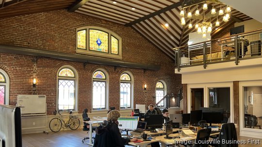
I recently stopped by the GoodMaps' office on Frankfort Avenue to talk with Reno-Weber and other members of the team about the release, as well as get a better idea of how the 3D scanning technology they use actually works.
When I spoke with Reno-Weber, she said the new app had approximately 20 maps available, with another 200 or so worldwide that are in the process of being added from the previous platform.
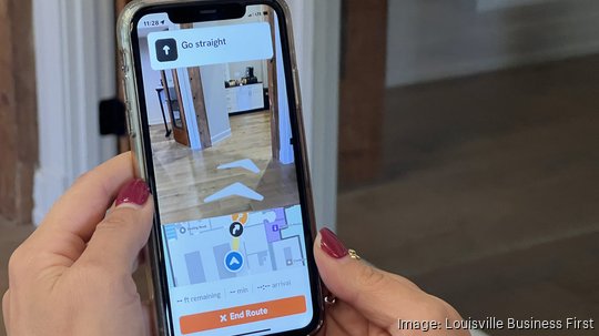
She demonstrated the technology on her own phone by using it to walk from her office to the women’s restroom. As she walked, an auditory guide gave instructions for each turn.
“And if you’re sighted, you can see the actual map,” she said. “You can see the floating arrows. You can see the turn-by-turn directions. … The upgrade for us is that it used to be purely auditory, and now there’s a visual component that if you’re sighted, you’re probably more used to with your old navigation apps.”
As we have chronicled, GoodMaps was founded in 2019 by the American Printing House for the Blind (APH), located right down the street from its current office space, under the name Access Explorer. Back then, its primary mission was serving the sight impaired through using LiDAR (Light Detection and Ranging) point clouds and images, which are able to be converted into digital maps of the interior of buildings.
These days, though, Reno-Weber said that her company is out to serve “anybody.”
“If you’re deaf, [a] visual [guide] is much more compelling to you. If you’re in a wheelchair, it’s helpful to see a visual map,” said Reno-Weber, who also mentioned the app has a step-free routing option to bring in elements such as elevators and ramps into the navigation.
As of a recent date, GoodMaps had mapped about 15 buildings in Louisville, including the Muhammad Ali International Airport, the Frazier History Museum, the Speed Art Museum, the Kentucky Science Center, Metro Hall and the KFC Yum! Center. On a global scale, the company has mapped train stations through the United Kingdom, office buildings in Canada and a Wal-Mart store in Mexico, just to name a few.
And how does the company map all of these locations?
As I walked up a flight of stairs at the office, I saw a photo of a guy that could best be described as a physical embodiment of a Google Maps car.
Then I met Elliott Holmes, the director of mapping operations who talked about the company’s latest 3D scanners, made by a German-based company called Leica.
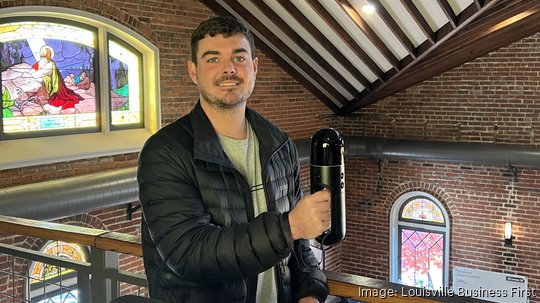
Holmes said GoodMaps has been using the scanners, which weigh slightly less than a cordless handheld vacuum, for about a year and a half.
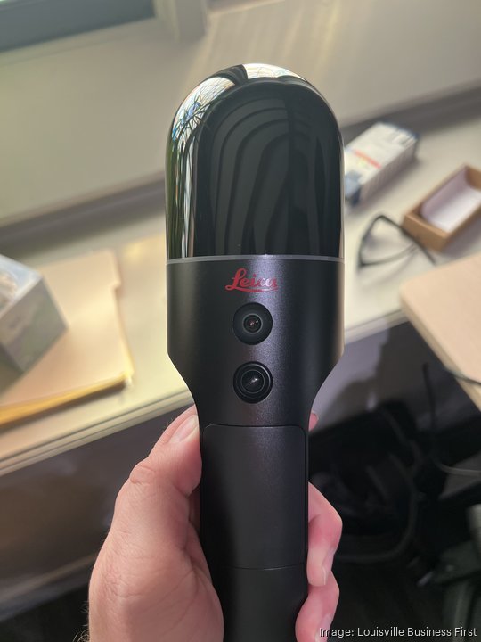
The exact scanner that it uses is a Leica BLK2GO, a device that anyone can purchase from the company’s store for $53,695.
Although the hardware is not proprietary, what GoodMaps does with the data in the form of algorithms and other formats very much is.
With a scanning radius of approximately 80 feet, the amount of time it takes depends on the size of the building. When the company mapped the 720,000 square-foot KFC Yum! Center, it was an all day process, whereas a much smaller building, such as the 5,000-square-foot office space of GoodMaps, can take minutes to scan and a few hours or less to process.
The scanner works by sending out light pulses in all directions in about 400,000 a second, Holmes said.
Once a building is scanned, the data — generated in what is known as a point cloud — is fed back to the home base where it is processed into maps.
“When we’re scanning, [we want to] replicate as many possible user positions in the building,” Holmes said. “I could walk a very quick lap around this building, and … get a good 3D dataset of it, but to localize people with the imagery, I actually have to grid pattern the floor, so that we can localize people anywhere.”
Holmes said even though GoodMaps uses hardware to record the 3D data sets, the imagery gathered combined with the company’s proprietary “sauce” allows the company “to be pioneers on the accuracy front” when creating indoor navigation.
“We’re guiding people,” he added, “much closer than hardware-based or beacon-based technology would."