One year after it announced its plans to create an underground infrastructure map of Chicago, City Digital — a collaboration of companies focused on cross-sector innovation in transportation, physical infrastructure, water and sanitation, and energy management — announced it has developed the technology to create a new underground infrastructure mapping program (UIM), and it will soon be used at a construction site in Chicago's River North neighborhood.
By improving the accuracy of information on Chicago's underground infrastructure, the underground map will be used to prevent accidents and delays due to inefficient construction when workers have to dig up the streets in the city, according to Chicago Department of Innovation and Technology (DoIT) Commissioner and CIO Brenna Berman in a recent press release.
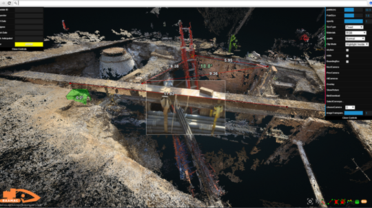
With partnership from Accenture, HBK Engineering and the City of Chicago, the pilot team has developed technology that includes advanced scanning tools, a data capture system and mobile applications that allow workers to update the system in real time, according to the release.
Although City Digital hopes to extend UIM to cities throughout the world, Chicago will be the first city to pilot the program, which is designed to monitor and create accurate 3D maps of underground properties such as pipes, gas lines, electrical systems and even legacy infrastructure — like old telephone lines — the news release said. It will generate, organize, visualize and store this data, which City Digital expects will allow cities and utilities to save millions of dollars in construction and planning processes, citing research from the American Public Works Association that says an underground utility line is hit every 60 seconds.
“Smart cities are about improving services and redesigning citizenship by providing better, seamless experiences," said Jay Hedley, Managing Director and Connected Spaces lead at Accenture Mobility. "Connecting the physical equipment underground with this digital solution will help citizens by increasing the efficiency of both planning and delivery of infrastructure projects.”
(Images via City Digital)