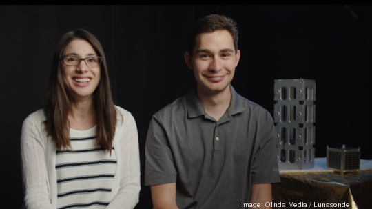
From researching Parkinson’s disease to building an “MRI scanner for planet Earth,” Jeremiah Pate is focused on solving big problems.
About seven years ago, the CEO and co-founder of Lunasonde was watching an archaeology documentary when he started to question the methods used to search for objects buried deep underground.
“They had all these scientists, and they were just looking for something underground, blindly drilling holes in the ground. I thought, ‘That's so strange. For the 21st century, you’d think there’d be a better way to look for something deep underground. Like, how come nobody's working on a Google Earth for the underground?’" Pate said. "As the years went by, I realized gradually that actually no one really had a solution to this problem.”
Pate said that traditional methods of resource exploration aren’t sustainable and disrupt the Earth’s ecosystem. Borehole drilling, for example, is one of the main ways to look beneath the Earth’s surface, but it’s incredibly destructive because holes have to be drilled into the ground. It also requires heavy equipment and massive teams to be present on site for the drilling.
Another option is seismic sensing, which requires explosives to be detonated at the surface level to see underground. The method can also create a lot of ambiguous signals, forcing scientists to deduce what they’re looking at.
“Those are the two best solutions,” said Pate, “and it kind of just goes downhill from there. So with Lunasonde, it actually allows us to do all of that, without ever stepping foot on that region. Our dream is that you can be in your office and on one continent, looking at your laptop and be seeing data from someplace all the way around the world.”
Lunasonde, which was incorporated in 2019, uses satellites approximately two kilometers underground to collect imagery for different companies or government organizations to see what is buried beneath the Earth’s surface.
The company utilizes a small satellite, called Gossamer, which contains a low frequency radar platform. This allows the company to create radio waves and see the reflections of those radio waves in order to look into the Earth.
With the technology, the company takes the uncertainty out of exploring for natural resources like minerals and water.
“Lunasonde’s mission is to fundamentally transform the way that we see our planet and its resources. And that's really because right now we have mapped the surface of Earth in exquisite detail. We know pretty much every square centimeter of our planet's surface. But at the same time, there's so much uncertainty about what lies just underneath us. And so Lunasonde really is allowing us to view the world in this entirely different way, seeing not just the dimensions of looking at a map, but seeing the depth of our planet, seeing resources, and other really important things under the ground,” said Pate.
Based in Cortaro, Arizona, Lunasonde participated in Techstars Boston 2020, and since then has been working to close its next round of fundraising. The company is also preparing to launch its first satellites this year — one definitely in December and it could possibly be launching one in October as well.
The company engages with customers in two different ways: They can either employ Lunasonde’s technology on a per-project basis, or through a subscription SaaS model.
The company initially aims to tackle water scarcity and unsustainable mining. The company’s technology can target a mineral vein without disturbing the surrounding area, allowing mining companies to avoid strip-mining areas to search and harvest for underground resources. And in terms of water scarcity, the company also allows water resource groups and governments to find aquifers more efficiently.
“One of the projects that we're working on is with the United States Geological Service, looking for aquifers and mapping aquifers underground here in Arizona, where our technology office is based out of," Pate said. "That's something that's very cool, just because it's geographically so close to where we are and also, water scarcity has been a problem in Arizona since the dawn of time, practically. So it's very satisfying to be able to address a problem that's literally in your backyard.”
Pate said that he hopes to one day apply the technology on a larger scale.
“In the future we see this as being capable of being used to look for, to map mineral assets at the level of countries, or actually do basically a global census, so to speak of the world's water supply. So things that are a bigger picture than that are potentially using this technology to look for resources on the Moon and Mars," he said. "Just because, as we expand out in space, finding those resources is incredibly important, just as it is on Earth and it also gives us a way to really industrialize space without having the environmental impact that we have on Earth.”