Tuesday morning marked the release of Facebook's Map With AI, a software tool that detects and marks roads based on satellite imagery.
Using the tool, a team based at Facebook Boston in Kendall Square identified all the previously unmapped roads in Thailand and more than 90 percent of those in Indonesia, according to a press release on Facebook's Tech@ blog. In the former, that was more than 300,000 miles of roads in 18 months. Without the AI software, Xiaoming Gao, a Facebook research scientist who helped lead the project, estimates that it would have taken another three to five years.
Map With AI is built on OpenStreetMap, one of the world's largest collaborative mapping efforts with a free API.
"We can never map the world, and keep it mapped, without assistance from machines," said Martijn van Exel, a longtime contributor to OpenStreetMap, in a press release on Facebook's AI blog. "The trick is to find the sweet spot. OSM is a people project, and the map is a reflection of mappers' interests, skills, biases, etc."
Facebook also released an open-source, AI-powered mapping tool called RapiD to the OpenStreetMap community. RapiD is an enhanced version of the OpenStreetMap editing tool iD.
The new software created by Facebook's AI team has been trained to identify possible roads and highlight them; then, human volunteers review those highlights and confirm or reject them. Bright magenta indicates very high confidence—on the software's part—that a pixel is part of a road.

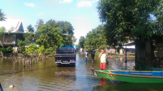
The big idea behind both Map With AI and RapiD is to build on Facebook's previous work to support disaster response efforts. That's part of the reason Facebook worked with human volunteers on the ground rather than relying solely on software. One road in Indonesia, for example, floods so badly each year that Map With AI couldn't identify it as a road—Indonesian volunteers told Facebook that (1) it is the area's main road and (2) residents navigate it with boats when it floods.
The software seems to have potential beyond Southeast Asia, too. The World Bank is interested in its applications.
“The World Bank applauds the use of AI-assisted feature extraction to help create worldwide geospatial data," said Walker Kosmidou-Bradley, a geographer at the World Bank, in the Tech@ blog. "We look forward to the expanded use of open geospatial data to enable data-based policy in developing countries."